
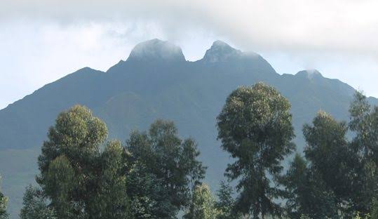
Mount Sabinyo Hiking in Uganda: The Ultimate Guide to the Three-Country Summit
Mount Sabinyo Hiking in Uganda: Conquer the Mountain of Three Peaks
Mount Sabinyo, also commonly spelled Mount Sabyinyo, is one of the most distinctive volcanoes in the Virunga Mountain Range. Located in southwestern Uganda within Mgahinga Gorilla National Park, this ancient volcanic mountain is famous for its rugged summit, steep ridges and the remarkable opportunity to stand at the meeting point of Uganda, Rwanda and the Democratic Republic of Congo.
Rising to approximately 3,669 metres above sea level, Mount Sabinyo is one of the most rewarding hiking destinations in the Virunga Conservation Area. Its jagged peaks resemble the worn teeth of an elderly person, inspiring the local name commonly translated as “Old Man’s Teeth.”
Unlike the smooth, symmetrical cones of neighbouring volcanoes, Sabinyo has an irregular summit with deep gorges, sharp ridges and challenging slopes. The hike takes visitors through bamboo forests, montane vegetation and high-altitude landscapes before reaching its three distinctive peaks.
For adventure travellers, Mount Sabinyo hiking offers more than a mountain climb. Reaching the third summit provides a rare geographical experience: standing at the border meeting point of three East African countries.
Where Is Mount Sabinyo Located?
Mount Sabinyo is part of the Virunga Volcanoes, a chain of volcanic mountains extending across Uganda, Rwanda and the Democratic Republic of Congo.
The mountain is located within the wider transboundary conservation landscape shared by three national parks:
- Mgahinga Gorilla National Park in Uganda.
- Volcanoes National Park in Rwanda.
- Virunga National Park in the Democratic Republic of Congo.
The mountain’s summit marks the meeting point of the three countries. However, the established tourist hiking route to its summit is accessed from the Ugandan side through Mgahinga Gorilla National Park.
The nearest major town is Kisoro in southwestern Uganda. The park entrance and hiking briefing point are at Ntebeko, where visitors meet their guides and park rangers before starting the climb.
Mount Sabinyo at a Glance
| Feature | Details |
|---|---|
| Mountain | Mount Sabinyo / Sabyinyo |
| Location | Mgahinga Gorilla National Park, Uganda |
| Mountain range | Virunga Mountains |
| Summit elevation | Approximately 3,669 metres |
| Local name | Old Man’s Teeth |
| Number of main peaks | Three |
| Hiking duration | Approximately 8 hours, depending on conditions |
| Hiking distance | Approximately 14 km round trip |
| Starting point | Ntebeko Visitor Centre |
| Main highlight | Three-country border summit |
| Hiking arrangement | Guided, with park ranger |
Elevation figures vary slightly between published references. Uganda Wildlife Authority’s environmental management documentation uses 3,669 metres for Sabinyo.
Why Is Mount Sabinyo Called Old Man’s Teeth?
The name Sabinyo is associated with a local word meaning tooth. The mountain’s unusual shape explains its nickname, “Old Man’s Teeth.”
Unlike the neighbouring volcanic peaks, which have more regular cone-shaped profiles, Mount Sabinyo has been heavily weathered over time. Its summit is divided into three jagged peaks that resemble worn teeth along an old man’s gumline.
These sharp ridges and deep valleys create the mountain’s distinctive appearance and make its hiking route particularly challenging.
The mountain is also considered one of the oldest volcanoes in the Virunga range. Its weathered landscape offers a striking contrast to the more symmetrical volcanic cones nearby.
The Three Peaks of Mount Sabinyo
Mount Sabinyo has three main summits, each offering a different perspective of the surrounding Virunga landscape.
1. First Peak: Uganda–Rwanda Border
The first summit takes hikers towards the Uganda–Rwanda border. It offers impressive views of the surrounding volcanic slopes, forested valleys and neighbouring mountains.
Reaching this point is an important milestone because the trail becomes increasingly demanding as hikers progress towards the higher peaks.
2. Second Peak: Rugged Volcanic Ridge
The second summit involves further climbing along steep ridges and exposed sections of the mountain.
Hikers encounter the distinctive terrain that makes Sabinyo famous, including sharp slopes, narrow sections and deep ravines. Wooden or metal ladders installed along particularly steep sections help visitors navigate parts of the route.
3. Third Peak: The Meeting Point of Three Countries
The third summit is the main highlight of Mount Sabinyo hiking.
At this point, the borders of Uganda, Rwanda and the Democratic Republic of Congo meet. Reaching the summit provides a rare opportunity to stand at the geographical meeting point of three countries.
The summit also rewards hikers with panoramic views of the Virunga landscape, including neighbouring volcanic peaks, forested slopes and valleys.
The final section can be particularly demanding, so hikers should follow the ranger’s instructions and only proceed when conditions and their physical ability allow.
Mount Sabinyo Hiking Experience: What to Expect
Mount Sabinyo hiking is a full-day mountain adventure that requires preparation, physical stamina and a willingness to navigate challenging terrain.
The trek normally starts early in the morning at Ntebeko Visitor Centre inside Mgahinga Gorilla National Park.
Morning Briefing at Ntebeko Visitor Centre
Hikers are expected to report to the park headquarters for registration and a briefing, commonly scheduled around 7:00 a.m.
During the briefing, park officials explain the mountain’s characteristics, hiking procedures, safety requirements and expected conduct.
Visitors are accompanied by trained guides and armed park rangers. The ranger’s role includes guiding the group, interpreting the environment and responding to potential wildlife encounters.
Porters are available for hire to help carry personal belongings, food and water.
Hiking Through the Bamboo Forest
The lower slopes of Mount Sabinyo pass through bamboo vegetation, an important habitat for golden monkeys.
This section introduces hikers to the rich biodiversity of Mgahinga Gorilla National Park. Depending on the conditions and wildlife movements, visitors may encounter birds and signs of other forest animals.
The bamboo forest provides a beautiful beginning to the climb before the landscape gradually changes with increasing elevation.
Exploring the Montane Forest
As hikers climb higher, they pass through montane forest vegetation, including areas characterised by Hagenia and Hypericum plants.
The forest becomes less dense as the trail approaches the upper mountain zones. This transition offers opportunities to observe different vegetation types and appreciate the ecological diversity of the Virunga landscape.
Reaching the High-Altitude Vegetation Zone
Above approximately 3,200 metres, the vegetation changes towards sub-alpine conditions, with fewer trees and more open high-altitude landscapes.
The higher slopes can be cold, windy and exposed to changing weather. Hikers should keep their rain protection and warm clothing accessible.
Climbing the Steep Ridges and Ladders
The upper sections of Mount Sabinyo are among the most challenging parts of the hike.
The trail crosses steep ridges and ravines, with ladders installed at selected sections to assist hikers. Some sections require careful movement and confidence when climbing.
Gardening gloves are useful for protecting your hands while holding ladders and navigating rough vegetation.
Reaching the Three-Country Summit
The final reward is reaching the third summit, where Uganda, Rwanda and the Democratic Republic of Congo meet.
Visitors can enjoy spectacular views of the surrounding mountains and valleys, subject to weather and visibility.
The summit is an excellent place for photography, but hikers should remain within the designated safe areas and follow the ranger’s instructions.
How Difficult Is Mount Sabinyo Hiking?
Mount Sabinyo is considered a challenging hike because of its steep slopes, uneven trails, sharp ridges and ladder sections.
Although the mountain is not the highest in the Virunga range, its rugged terrain makes it physically demanding.
The difficulty is influenced by several factors:
- Steep ascents: Some sections involve sustained uphill climbing.
- Ladders: Hikers must negotiate ladders along steep and exposed parts of the trail.
- Uneven terrain: The route crosses rocky ground, narrow ridges and muddy forest paths.
- Altitude: The summit is approximately 3,669 metres above sea level, where some visitors may experience altitude-related symptoms.
- Weather: Rain, wind, mist and cold temperatures can make the hike more difficult.
A reasonable level of physical fitness is recommended. Previous hiking experience is useful, particularly for visitors who are uncomfortable with heights or steep ladders.
Travellers with heart, respiratory, mobility or other relevant health concerns should seek medical advice before attempting the climb.
How Long Does It Take to Hike Mount Sabinyo?
Mount Sabinyo hiking generally takes approximately eight hours for the round trip, with around four hours of ascent and four hours of descent under favourable conditions.
The commonly published route distance is approximately 14 kilometres.
However, the actual duration depends on:
- The fitness and walking pace of the group.
- Weather conditions.
- Trail conditions.
- Time spent resting.
- The ability of hikers to negotiate the ladders and steep sections.
Visitors should not treat eight hours as a guaranteed completion time. The ranger may adjust the route or require the group to turn back if conditions become unsafe.
Some local hiking guidance advises descending if hikers have not reached the first peak by approximately 1:00 p.m., to avoid returning after dark. Follow the current instructions provided by park authorities on the day.
Mount Sabinyo Hiking Permit and Cost
Mount Sabinyo hiking is a regulated activity within Mgahinga Gorilla National Park. Visitors must arrange the appropriate hiking activity and pay the applicable Uganda Wildlife Authority fees.
The amount payable can depend on the visitor category and the current conservation tariff.
Some online visitor information still displays older rates, so travellers should not rely on outdated prices when planning a 2026 or 2027 hike.
Before booking, confirm the following with Uganda Wildlife Authority or an authorised safari operator:
- Current Mount Sabinyo hiking fee.
- Whether the guide and ranger fees are included.
- Whether park entry is charged separately.
- Porter charges.
- Available hiking dates and reporting time.
- Any current restrictions or changes to the route.
A porter is generally hired separately from the hiking activity. Ask for a complete quotation so you understand which services are included.
Booking advice: Reserve your hiking activity in advance, particularly when combining Mount Sabinyo with gorilla trekking or golden monkey tracking.
Best Time to Hike Mount Sabinyo
Mount Sabinyo can be hiked throughout the year, but weather conditions influence the difficulty and enjoyment of the experience.
The drier periods are generally more favourable because the trails may be less muddy and slippery.
June to August
June to August is one of the popular periods for hiking in Mgahinga. Conditions are often relatively drier, making it a suitable time for visitors interested in climbing the mountain.
However, cold temperatures, mist and rainfall can still occur.
December to February
December to February is another favourable period for hiking. Visitors may experience more manageable trail conditions, although the weather remains unpredictable at higher elevations.
March to May
This period generally receives more rainfall. Trails can become muddy and slippery, particularly along the steeper sections.
Hiking is still possible when park authorities consider conditions suitable, but visitors should be prepared for rain and slower progress.
September to November
Rainfall can also affect hiking during these months. The vegetation is often lush, but wet conditions may make the ladders, ridges and forest trails more challenging.
Overall recommendation: June to August and December to February are generally preferred for Mount Sabinyo hiking. Nevertheless, no month guarantees dry weather, so always prepare for rain.
What to Pack for Mount Sabinyo Hiking
Proper hiking equipment is essential for a safe and comfortable mountain adventure.
Recommended items include:
- Waterproof hiking boots with good grip.
- Long hiking trousers.
- Long-sleeved hiking shirt.
- Gardening gloves for holding ladders and rough surfaces.
- Waterproof jacket or rain poncho.
- Warm clothing for the cold upper slopes.
- Drinking water.
- Packed lunch and energy-giving snacks.
- Small backpack.
- Sun protection, including a hat and sunscreen.
- Sunglasses.
- Personal medication and a basic first-aid kit.
- Camera or smartphone with sufficient battery.
- Walking stick, subject to the park’s arrangements.
Avoid carrying unnecessary luggage because the climb is physically demanding.
Hiring a local porter is recommended. Porters can carry your backpack and help you negotiate difficult sections of the trail. Their services also provide income opportunities for people living around the park.
Where to Stay for Mount Sabinyo Hiking
Visitors planning to climb Mount Sabinyo should consider staying close to Mgahinga Gorilla National Park or in the nearby Kisoro area.
An overnight stay before the hike is recommended because the activity begins early in the morning.
Luxury Accommodation
Mount Gahinga Lodge
Mount Gahinga Lodge is a luxury accommodation option near the Ntebeko entrance. Its location makes it convenient for travellers planning volcano hiking, gorilla trekking and golden monkey tracking.
Midrange Accommodation
Lake Mulehe Safari Lodge
Located near Lake Mulehe in the Kisoro area, this lodge is an option for visitors seeking comfortable accommodation while exploring Mgahinga and the surrounding highlands.
Mutanda Lake Resort
Mutanda Lake Resort offers a scenic lakeside setting overlooking Lake Mutanda and the surrounding volcanic landscape. It is suitable for travellers who want to combine hiking with relaxation.
Budget and Community-Based Accommodation
Amajambere Iwacu Community Camp
This community-based accommodation option is located near Mgahinga and is suitable for travellers looking for a simpler stay close to the park.
Accommodation in Kisoro Town
Kisoro has several hotels and guesthouses for visitors who prefer to stay in town. When booking, consider the early morning transfer to Ntebeko Visitor Centre.
Accommodation availability and current rates should be confirmed directly before travel.
How to Get to Mount Sabinyo
Mount Sabinyo is accessed through Mgahinga Gorilla National Park in southwestern Uganda. Travellers can reach the park by road or domestic flight.
From Kampala or Entebbe
The journey from Kampala or Entebbe to Kisoro is approximately 500 kilometres, depending on the route. A road transfer generally takes around 9–10 hours, although traffic, road conditions and stopovers may extend the journey.
The common route passes through Masaka, Mbarara, Kabale and Kisoro.
From Kisoro, continue to Ntebeko Visitor Centre, the starting point for the Mount Sabinyo hike.
It is advisable to arrive a day before the scheduled hike.
By Air
Visitors can arrange a domestic flight from Entebbe to Kisoro Airstrip, subject to airline schedules and operating conditions.
A road transfer is then required from the airstrip to the lodge and park entrance.
This option is useful for travellers with limited time who want to reduce the long road journey.
From Kigali, Rwanda
Mount Sabinyo can also be reached from Kigali through the Cyanika border crossing into Uganda, followed by a road transfer to Kisoro and Mgahinga.
This route is useful for visitors combining Rwanda and Uganda in one safari. Travellers should confirm visa requirements, border procedures and vehicle arrangements before departure.
Other Activities to Combine with Mount Sabinyo Hiking
A visit to Mgahinga Gorilla National Park can include several other wildlife and cultural experiences.
1. Mountain Gorilla Trekking
Mgahinga is home to the habituated Nyakagezi Gorilla Family, known for its history of movements within the Virunga region.
Gorilla trekking provides an opportunity to observe endangered mountain gorillas in their natural habitat.
The activity requires a separate gorilla trekking permit and should be arranged for a different day from the demanding Mount Sabinyo hike.
Read more about gorilla trekking in Mgahinga National Park.
2. Golden Monkey Tracking
Golden monkeys are among the most attractive primates in Mgahinga. They inhabit the bamboo forests on the slopes of the Virunga Volcanoes.
Visitors can join a guided tracking experience to observe these lively monkeys feeding, jumping between bamboo stems and interacting with one another.
Golden monkey tracking is an excellent addition to a longer Mgahinga safari.
3. The Batwa Cultural Experience
The Batwa cultural experience introduces visitors to the history, forest knowledge and cultural heritage of the Batwa Indigenous people.
Through a guided community experience, visitors can learn about traditional forest practices, medicinal plants, food gathering, storytelling and the Batwa’s historical relationship with the Mgahinga landscape.
Visitors are encouraged to approach the experience respectfully and support community-led tourism initiatives.
4. Birdwatching
Mgahinga supports several montane forest and Albertine Rift bird species. Birdwatchers may look for the Rwenzori Turaco, Rwenzori Batis, Kivu Ground Thrush and other highland birds.
The higher vegetation zones around Mount Sabinyo offer interesting opportunities for birding.
5. Mount Gahinga Hiking
Mount Gahinga is another volcano within Mgahinga Gorilla National Park. It rises to approximately 3,474 metres and features bamboo forest, montane vegetation and a crater swamp near its summit.
The climb provides a different hiking experience from the rugged ridges of Mount Sabinyo.
6. Mount Muhabura Hiking
Mount Muhabura is the highest of the three volcanoes in Mgahinga, rising to 4,127 metres above sea level.
Its steep slopes and high altitude make it a demanding hiking destination. The summit features a crater lake and offers expansive views when weather conditions are favourable.
7. Lake Mutanda
Lake Mutanda is a scenic highland lake near Kisoro, surrounded by rolling hills and views of the Virunga Volcanoes.
Visitors can enjoy canoeing, boat excursions, birdwatching and lakeside relaxation after a challenging mountain hike.
Suggested 3-Day Mount Sabinyo Hiking Safari
A three-day safari provides enough time to travel to Mgahinga, climb Mount Sabinyo and explore another attraction in the region.
Day 1: Transfer to Mgahinga Gorilla National Park
Travel from Kampala, Entebbe or Kigali to Kisoro. Enjoy the scenic countryside and highland landscapes before arriving at your lodge near the park.
Spend the evening relaxing and preparing your hiking equipment for the following morning.
Day 2: Mount Sabinyo Hiking
After an early breakfast, transfer to Ntebeko Visitor Centre for registration and briefing.
Begin the guided hike through the bamboo forest and montane vegetation, continuing towards the three peaks of Mount Sabinyo.
The climb includes steep ridges, ladders and challenging sections. If conditions and your fitness allow, continue to the third summit at the Uganda–Rwanda–DR Congo meeting point.
Return to the park headquarters with your guide and transfer back to the lodge.
Day 3: Golden Monkey Tracking and Departure
After breakfast, enjoy an optional golden monkey tracking experience in Mgahinga, subject to permit availability and scheduling.
After the activity, begin your return journey to Kisoro, Kampala or Entebbe. Alternatively, extend your safari to Lake Mutanda or Bwindi Impenetrable National Park.
Safety Tips for Mount Sabinyo Hiking
Mount Sabinyo is a challenging mountain, and safety should be a priority throughout the experience.
- Follow the instructions of your UWA guide and ranger.
- Do not attempt to climb beyond the designated trail.
- Use ladders carefully and maintain appropriate spacing between hikers.
- Wear hiking boots with good grip.
- Carry enough drinking water and food.
- Keep rain protection and warm clothing accessible.
- Avoid rushing through steep sections.
- Inform the guide if you feel unwell, dizzy or unusually exhausted.
- Do not continue if the ranger advises the group to turn back.
- Avoid hiking alone or without the required park arrangements.
Because the mountain reaches a high elevation, visitors should be aware of possible altitude-related symptoms, including headache, nausea, dizziness and unusual fatigue. Report symptoms to the guide promptly and follow their advice.
Why Book Your Mount Sabinyo Hiking Safari with Epic Uganda Vacation?
Epic Uganda Vacation helps travellers explore Uganda through tailor-made hiking, wildlife and cultural experiences.
We can organise a Mount Sabinyo hiking safari that combines the mountain adventure with other attractions in southwestern Uganda.
Our safari planning assistance includes:
- Arranging the appropriate hiking activity with the relevant authorities.
- Organising private transport to Mgahinga.
- Recommending accommodation near the park.
- Coordinating local guides and porter arrangements.
- Combining the hike with gorilla trekking and golden monkey tracking.
- Extending the itinerary to Lake Mutanda, Lake Bunyonyi or Bwindi.
- Preparing private itineraries based on your travel dates and budget.
Whether you are an experienced hiker or an adventurous traveller looking for a challenging Virunga experience, we can help you plan your visit.
Contact Epic Uganda Vacation to arrange your Mount Sabinyo hiking adventure:
https://www.epicugandavacation.com/contact-us/
Frequently Asked Questions About Mount Sabinyo Hiking
1. Where is Mount Sabinyo located?
Mount Sabinyo is located in the Virunga Mountains, within the landscape shared by Uganda, Rwanda and the Democratic Republic of Congo. The established tourist hiking route is accessed from Mgahinga Gorilla National Park in southwestern Uganda.
2. How high is Mount Sabinyo?
Mount Sabinyo’s summit is approximately 3,669 metres above sea level. Some published references use a slightly different elevation figure.
3. Why is Mount Sabinyo called Old Man’s Teeth?
The name refers to the mountain’s jagged peaks, which resemble the worn teeth of an elderly person.
4. Can you stand in three countries at the summit of Mount Sabinyo?
Yes. The third summit is at the meeting point of Uganda, Rwanda and the Democratic Republic of Congo. Hikers who reach this point can stand at the three-country border area.
5. How long does Mount Sabinyo hiking take?
The hike generally takes approximately eight hours for the round trip, although the actual duration depends on weather, fitness, trail conditions and the pace of the group.
6. How far is the Mount Sabinyo hiking trail?
The commonly published round-trip hiking distance is approximately 14 kilometres.
7. Is Mount Sabinyo difficult to climb?
Yes. It is a challenging hike involving steep slopes, narrow ridges, deep ravines and ladders. A reasonable level of physical fitness and suitable hiking experience are recommended.
8. Can Mount Sabinyo be climbed from Rwanda or the Democratic Republic of Congo?
The established tourist hiking route to the three summits is accessed from the Ugandan side through Mgahinga Gorilla National Park. Its rugged terrain makes access from the other sides difficult.
9. What is the best time to hike Mount Sabinyo?
June to August and December to February are generally preferred because conditions are often drier. However, rainfall can occur throughout the year.
10. What should I wear for Mount Sabinyo hiking?
Wear waterproof hiking boots, long trousers, a long-sleeved shirt, gardening gloves and a waterproof jacket. Carry warm clothing because temperatures can be low at higher elevations.
11. Do I need a guide to climb Mount Sabinyo?
Yes. The hike is conducted under the park’s guided arrangements. Visitors should register at Ntebeko Visitor Centre and follow the instructions of the park guides and rangers.
12. Can I combine Mount Sabinyo hiking with gorilla trekking?
Yes. You can combine the hike with mountain gorilla trekking in Mgahinga or Bwindi, as well as golden monkey tracking. These activities require separate arrangements and sufficient time for recovery.
Conclusion: Experience the Three-Country Summit of Mount Sabinyo
Mount Sabinyo is one of the most remarkable hiking destinations in Uganda’s Virunga region. Its rugged volcanic landscape, challenging ridges, steep ladders and three distinctive peaks make it an unforgettable adventure for mountain enthusiasts.
The greatest reward comes at the third summit, where Uganda, Rwanda and the Democratic Republic of Congo meet. Standing at this unique border point while overlooking the surrounding volcanic landscape is an experience that makes the demanding climb worthwhile.
Beyond the summit, hikers can discover the biodiversity of Mgahinga Gorilla National Park, including bamboo forests, montane vegetation and remarkable birdlife. Combining the hike with gorilla trekking, golden monkey tracking or a Batwa cultural experience makes the visit even more rewarding.
Plan your Mount Sabinyo hiking safari with Epic Uganda Vacation and discover one of the most extraordinary mountain adventures in East Africa.
Related posts:
 Kanyanchu Visitor Center | Kibale Chimpanzee Trekking
 Budongo Central Forest Reserve | Chimpanzee Tracking & Birdwatching
 Nyakagezi Gorilla Family in Uganda | Mgahinga Gorilla Trekking
 Bitukura Gorilla Family in Bwindi, Uganda | Ruhija Sector
 Rushegura Gorilla Family in Bwindi, Uganda | Buhoma Gorilla Trek