Ol Doinyo Lengai, Tanzania: Things to Do, Weather, Best Time to Visit and Packing Guide
Introduction: Discover Ol Doinyo Lengai, the Mountain of God
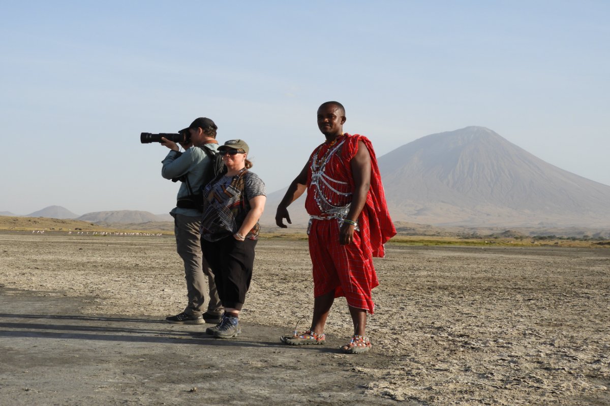
Ol Doinyo Lengai is one of Tanzania’s most distinctive natural landmarks, rising dramatically above the plains south of Lake Natron in the Great Rift Valley. Known as the “Mountain of God” in the Maasai language, this active volcano attracts adventurous travellers, hikers, photographers and visitors interested in Tanzania’s remarkable geological landscapes.
At approximately 2,962 metres (9,718 feet) above sea level, Ol Doinyo Lengai offers sweeping views across the Rift Valley, Lake Natron and the surrounding volcanic terrain. Its steep, loose slopes make the climb physically demanding, but the sunrise views from the summit can be an extraordinary reward for well-prepared hikers. The volcano is also scientifically significant because it is the only known volcano to erupt natrocarbonatite lava.
For travellers planning a northern Tanzania adventure, Ol Doinyo Lengai can be combined with Lake Natron, Ngare Sero Waterfalls, local Maasai cultural experiences and other destinations in the northern safari circuit.
Where Is Ol Doinyo Lengai Located?
Ol Doinyo Lengai is located in northern Tanzania, in the Gregory Rift Valley, just south of Lake Natron. The mountain stands within a striking landscape of volcanic hills, dry plains, escarpments and alkaline lake shores.
The journey to the area is part of the adventure. Travellers commonly approach through the Lake Natron and Engaresero area, often using a 4×4 vehicle because some access roads are rough and conditions can deteriorate after rain.
Ol Doinyo Lengai is commonly visited as part of a multi-day trip from Arusha or as an extension to a northern Tanzania safari. Allow enough time for the road journey, rest before the climb, and recovery afterwards rather than treating the summit hike as a casual day excursion.
Top Things to Do at Ol Doinyo Lengai
1. Climb Ol Doinyo Lengai for Sunrise
The main attraction is the challenging hike to the volcano’s summit. Most organised climbs begin late at night or around midnight, depending on local arrangements and conditions. Starting in darkness helps hikers avoid the worst daytime heat and aims to bring them to the upper mountain around sunrise.
The route is steep, with loose volcanic ash and crumbly rock that can make progress difficult. The descent is also demanding, particularly as temperatures rise.
From the summit area, hikers may enjoy expansive views of Lake Natron, the Rift Valley escarpments and the surrounding volcanic landscape when the weather is clear.
Important: This is a strenuous mountain climb, not an easy guided walk. A guide should assess conditions before departure, and the climb should be postponed if volcanic activity, weather, route conditions or a hiker’s health make it unsafe.
2. Explore Lake Natron
Lake Natron lies near the foot of Ol Doinyo Lengai and is famous for its mineral-rich alkaline water, striking colours and importance as a breeding area for lesser flamingos.
The lake and its surrounding mudflats create an unusual landscape that contrasts with the dark volcanic slopes. Depending on the season and water conditions, visitors may see flamingos and other birds, photograph the lake’s changing colours, or take a guided walk along suitable sections of the shore.
Flamingo numbers and viewing opportunities vary with water levels, breeding conditions and the season, so wildlife sightings should never be guaranteed.
Safety note: Lake Natron’s alkaline water can be hazardous. Do not swim in the lake or allow water to enter your eyes or mouth.
3. Visit Ngare Sero Waterfalls
The Ngare Sero gorge and waterfalls offer a refreshing contrast to the hot, dry landscape around Lake Natron. With a local guide, visitors can follow a rocky route through the gorge to see flowing water, dramatic rock formations and shaded sections of the valley.
The walk can involve uneven rocks, water crossings and slippery surfaces. Wear shoes with reliable grip and follow your guide’s advice about water levels and safe routes. Swimming should only be considered where local guides confirm that conditions are safe.
4. Discover Maasai Culture
The area around Ol Doinyo Lengai is part of the traditional homeland of Maasai communities. A respectful, locally arranged cultural visit can help visitors learn about pastoral life, local traditions, the relationship between communities and their landscape, and the significance of the mountain.
Choose experiences organised with community participation, ask permission before taking photographs, and follow local guidance at culturally important sites. Ol Doinyo Lengai is not simply a scenic mountain; it also holds spiritual significance for local communities.
5. Explore the Great Rift Valley Landscape
The wider Lake Natron region offers a fascinating introduction to the geology of the East African Rift. Travellers can see escarpments, volcanic features, unusual rock formations and broad open plains shaped by geological processes over long periods.
The official Ngorongoro Lengai Geopark route highlights geological and cultural stops in the region, including the Engaruka ruins, tufa towers, Rift Valley viewpoints and the Engaresero footprint site. Availability and access should be confirmed locally when planning your itinerary.
6. Visit the Ancient Footprints Near Engaresero
The Engaresero area is known for preserved ancient human footprints in volcanic deposits. These tracks offer a remarkable connection to people who lived in the region thousands of years ago.
A visit can add an archaeological dimension to a trip focused on volcanoes and landscapes. Arrange access through a knowledgeable local guide and respect any restrictions intended to protect the site.
7. Photograph the Volcano and Lake Natron
Ol Doinyo Lengai is especially photogenic at sunrise and sunset, when changing light highlights its steep volcanic cone and the surrounding Rift Valley. Lake Natron provides additional opportunities for landscape and bird photography.
Bring a camera or phone with sufficient battery power, a power bank and a way to protect equipment from dust. Use a lens cloth to clean dust from camera equipment, and avoid approaching birds or other wildlife too closely.
Ol Doinyo Lengai Weather: What Should You Expect?
The Ol Doinyo Lengai region has a generally hot, dry lowland climate, but conditions change with elevation, season, wind and time of day. The lower slopes can be extremely hot, while the summit may feel cold and windy before sunrise.
This contrast is one of the most important things to understand before planning the climb. You may start hiking in cool night air, reach the upper mountain in chilly conditions, and descend into intense heat later in the morning.
Typical seasonal conditions
| Period | General conditions | Travel considerations |
|---|---|---|
| June–August | Generally drier, with cooler nights and potentially cold summit winds | Carry warm layers and confirm trail conditions |
| September–October | Often dry and hot, although seasonal changes can occur | Start early and monitor heat and weather forecasts |
| November–December | Short rains may occur | Check road access and whether rain has made slopes slippery |
| January–February | Often a comparatively dry period, though conditions vary | Can be suitable for planning, subject to local advice |
| March–May | Main rainy season in much of northern Tanzania | Muddy roads, rain and slippery volcanic terrain may complicate the climb |
This is a broad seasonal guide, not a daily forecast. Actual conditions vary from year to year, and rainfall patterns do not always follow a fixed calendar.
What is the best weather for climbing Ol Doinyo Lengai?
Dry conditions are generally preferable because loose volcanic ash and rock can become more dangerous when wet. Clear skies also improve the chance of enjoying sunrise and distant views.
However, a dry-season date does not guarantee a safe climb. Wind, temperature, volcanic activity, visibility and the condition of the access roads should all be checked shortly before travel.
Because Ol Doinyo Lengai is an active volcano, confirm current volcanic conditions and local climbing advice before setting out.
Best Time to Visit Ol Doinyo Lengai
Many travellers favour the drier periods, particularly around June to October and January to February, for hiking and exploring the Lake Natron area. These periods can offer more favourable road and trail conditions, although heat may still be intense.
The rainy periods can bring beautiful scenery but may also create access challenges and slippery slopes. If you plan to travel during or near the rainy season, build flexibility into your itinerary.
For the best overall experience, plan to:
- Arrive in the Lake Natron area at least a day before the climb.
- Rest and hydrate before the night hike.
- Allow time to recover after the descent.
- Keep an alternative activity available in case the climb is cancelled.
What to Pack for Ol Doinyo Lengai
Packing for Ol Doinyo Lengai requires preparation for darkness, loose volcanic terrain, cold summit winds, dust and hot daytime temperatures. Keep your hiking pack manageable, but do not leave out essential safety equipment.
Essential hiking equipment
- Sturdy hiking boots: Choose well-fitting boots with ankle support and good traction. Break them in before the trip.
- Headlamp: Carry a reliable headlamp with fresh batteries, plus a backup light or spare batteries.
- Water: Carry sufficient drinking water for the full hike. Around 3–4 litres is a useful planning starting point for many hikers, but your guide should advise on your needs, duration and conditions.
- Electrolytes and snacks: Bring energy bars, nuts, dried fruit or other easy-to-eat snacks, along with electrolyte replacement if appropriate.
- Trekking poles: These can help with balance and reduce strain on the descent.
- Small backpack: A comfortable daypack of roughly 20–30 litres is usually practical for personal essentials.
Clothing to bring
- Moisture-wicking hiking shirt.
- Lightweight hiking trousers.
- Warm fleece or insulating layer.
- Windproof jacket for the summit.
- Warm hat and lightweight gloves.
- Sun hat for the descent.
- Spare socks.
- Buff or neck gaiter to reduce dust exposure.
- Light rain jacket if travelling when showers are possible.
Layering is essential. You need clothing that works in cool pre-dawn conditions and can be adjusted as the temperature rises.
Sun and personal protection
- High-protection sunscreen.
- Sunglasses.
- Lip balm.
- Personal medication.
- Blister plasters and a small first-aid kit.
- Dust protection, such as a suitable face covering.
- Insect repellent for evenings around the lake and accommodation.
Travel documents and practical items
- Passport and any required travel documents.
- Travel insurance that explicitly covers strenuous hiking and relevant evacuation arrangements.
- Phone and power bank.
- Camera and protective case.
- Small amount of Tanzanian shillings for local purchases and tips.
- Reusable water bottles or a hydration system.
- Comfortable clothes and sandals for your lodge or camp.
Before departure: Ask your operator for the latest equipment list. Your guide may recommend additional items based on the route, weather and current conditions.
How Difficult Is the Ol Doinyo Lengai Climb?
The climb is considered strenuous because the slope is steep, the ground is often loose, and much of the ascent takes place at night. The descent can be equally challenging due to fatigue, loose ash and rising daytime temperatures.
You should be comfortable with prolonged uphill walking and have good general fitness before attempting it. Previous hiking experience is strongly recommended.
Ol Doinyo Lengai may not be suitable for people with significant mobility limitations, inadequate fitness, or medical conditions that could be aggravated by strenuous exercise, heat or altitude. Seek medical advice if you are unsure whether the climb is appropriate for you.
Unlike a well-developed mountain trail, the route may have limited infrastructure and rescue support. Confirm the emergency plan with your guide, carry appropriate supplies and never climb alone.
How to Get to Ol Doinyo Lengai
Many visitors begin their journey in Arusha and travel towards Lake Natron via the northern Tanzania Rift Valley. The journey can take much of a day depending on the route, road conditions, stops and starting point.
A 4×4 vehicle is often recommended for the rougher sections. During rainy periods, road conditions may change quickly, so ask your operator to confirm access shortly before travel.
The most practical plan is usually to stay near Lake Natron before the climb. This allows time to meet the local guide, prepare equipment, rest and begin the ascent at the appropriate hour.
Travellers can combine Ol Doinyo Lengai with Lake Natron, Ngare Sero Waterfalls and other northern Tanzania destinations. If combining the mountain with a wildlife safari, avoid scheduling a long game drive immediately after the climb; fatigue and recovery time matter.
Suggested 3-Day Ol Doinyo Lengai and Lake Natron Itinerary
Day 1: Arusha to Lake Natron
Depart Arusha and travel towards Lake Natron through the Rift Valley landscape. Enjoy scenic stops where road and time conditions permit, then arrive at your camp or lodge.
Meet your local guide, check the weather and climbing arrangements, organise your equipment and get some rest before the night ascent.
Day 2: Ol Doinyo Lengai Summit Hike
Begin the climb late at night or around midnight, according to your guide’s schedule and the latest conditions. Ascend slowly over steep volcanic terrain, aiming for the summit area around sunrise if conditions allow.
After enjoying the views, descend carefully and return to your accommodation for rest, food and recovery. The exact duration varies with fitness, route conditions and the group’s pace.
Day 3: Ngare Sero Waterfalls and Return Journey
After breakfast, visit Ngare Sero gorge and waterfalls with a local guide, or choose a gentler activity if you need more recovery time. Depending on access arrangements, you may also explore the Lake Natron area or visit a cultural or geological site.
Continue to your next destination or return towards Arusha. Additional nights are recommended if you want a more relaxed trip.
This itinerary is a planning example, not a guarantee of access or summit success. Activities should be adjusted to current volcanic, weather and road conditions.
Responsible Travel at Ol Doinyo Lengai
Ol Doinyo Lengai is an active geological environment and a culturally significant mountain. Responsible travel helps protect both the landscape and the communities who live around it.
- Use experienced local guides and follow their safety instructions.
- Respect local customs and ask permission before photographing people.
- Keep to agreed routes and avoid damaging geological or archaeological features.
- Carry out all rubbish, including food wrappers and batteries.
- Do not approach active volcanic features or touch unfamiliar volcanic material.
- Avoid disturbing flamingos and other wildlife around Lake Natron.
- Support locally operated accommodation, guiding and community activities where possible.
Frequently Asked Questions About Ol Doinyo Lengai
Is Ol Doinyo Lengai an active volcano?
Yes. Ol Doinyo Lengai is an active volcano, and the Smithsonian Global Volcanism Program records ongoing eruptive activity into 2026. Conditions can change, so check the latest authoritative volcanic updates and local advice before travelling. Do not approach the crater or attempt the climb if authorities or guides advise against it.
How high is Ol Doinyo Lengai?
The summit is approximately 2,962 metres (9,718 feet) above sea level.
How long does it take to climb Ol Doinyo Lengai?
The climb commonly involves an overnight ascent and a descent during the morning. Total time varies with fitness, route conditions, weather and the guide’s schedule. Confirm the expected duration before booking and allow additional time for rest afterwards.
What should I wear to climb Ol Doinyo Lengai?
Wear sturdy hiking boots, lightweight hiking clothes and layers. Bring a warm fleece, windproof jacket, hat and gloves for the summit, plus sun protection for the descent.
Do I need a guide to climb Ol Doinyo Lengai?
A knowledgeable local guide is strongly recommended. The terrain is steep and loose, the hike starts in darkness, and the volcano is active. Confirm current access arrangements and follow the guide’s decision if conditions are unsafe.
Can I climb Ol Doinyo Lengai during the rainy season?
Rain can make volcanic ash and loose slopes slippery and may affect road access. Some trips may be postponed or cancelled. Check current conditions and avoid attempting the climb when your guide considers it unsafe.
Can Ol Doinyo Lengai be combined with Lake Natron?
Yes. Lake Natron is close to the mountain and is a natural addition to the trip. Visitors can plan birdwatching, landscape photography, guided gorge walks and cultural experiences, depending on conditions and available time.
Is Ol Doinyo Lengai suitable for beginners?
It is not an easy beginner’s hike. The steep, loose terrain, night start and hot descent demand fitness, preparation and careful guidance. Travellers without suitable hiking experience should discuss their ability and alternatives with their operator before booking.
Plan Your Ol Doinyo Lengai Adventure with EPIC UGANDA VACATION LTD
Ol Doinyo Lengai offers a different side of East Africa: a dramatic active volcano, the flamingo landscapes of Lake Natron, the scenery of the Great Rift Valley and opportunities to connect with local culture.
EPIC UGANDA VACATION LTD can help travellers explore East Africa through carefully planned safari and adventure itineraries. If you are interested in adding Ol Doinyo Lengai and Lake Natron to a northern Tanzania journey, contact our team to discuss route options, local guiding, accommodation and travel dates.
Start planning your East African adventure with EPIC UGANDA VACATION LTD.